
Applicai Consulting · permits and land-use approvals
An agent on your side, from first question to approval
Building, subdividing or changing how your land is used means dealing with the regional district or municipality — and often the Ministry of Transportation or the Agricultural Land Commission as well. Jay Simpson acts as your agent: he finds out what your property allows, works with your surveyor, designer and builder, and assembles and submits your applications — with you in the loop at every step. The decisions stay yours.
What Jay does for you
-
Finds out what your property allows
Zoning, setbacks, slope, water, the Agricultural Land Reserve, covenants on title — checked before you spend money on design, so you know what is possible and what will need an application.
-
Deals with the authorities for you
With your written authorisation, Jay is the point of contact for regional district or municipal staff, the Ministry of Transportation, Agricultural Land Commission and more. Their letters and questions come to him first; he shares each one with you and explains what it means.
-
Gets the permits and approvals
He completes the application forms for you, gathers the drawings and reports from your professionals and assembles the package. He goes through it with you, and nothing goes to the regional district or any other authority without your OK. Then he answers what the planner comes back with until it is approved.
-
Works with your professionals
Your surveyor, architect or designer, builder and engineers do the drawings and reports. Jay tells them what the authority requires, collects their work and makes sure it answers what was asked — and you’re in the loop at every step. If you still need someone, he helps you find qualified local firms and compare quotes.
-
Sets out your decisions plainly
When there is more than one way forward, you get the options in plain language — what each involves and, where known, what it costs and how long it’s likely to take — and you choose.
-
Keeps you informed
Jay is available to answer your questions, and keeps you up to date on where your application stands and what’s coming next.
How it works
-
Tell Jay about your property
Where it is, what you would like to do, and anything you have already heard from the regional district or municipality.
-
Find out what the land allows
Jay looks at the property, its zoning and its terrain, and tells you what is possible, what will need approval, and the likely route.
-
Your professionals, and the paperwork
Jay keeps in touch with you, your surveyor, designer and other professionals about what the authority needs, collects their drawings and reports, and completes the forms. Once everything is in, he goes through the package with you and, once you approve, submits it.
-
Apply and follow through
Once you’ve given the OK, Jay submits, handles the back-and-forth with staff, and keeps you up to date until the permit or approval is issued.
Two examples

A first look at the land, before you buy or design
Before you commit to a purchase or a design, Jay takes a first look at what the land allows — slopes, contours, water and zoning. This one is a 1.23-hectare parcel zoned Country Residential: the dashed line is the property, the brown lines are contours, and the panel sums up the ground — it falls gently to the southeast, and 95% of it is under 15% slope.
Source: CSRD map services, read . Indicative only — not a survey.

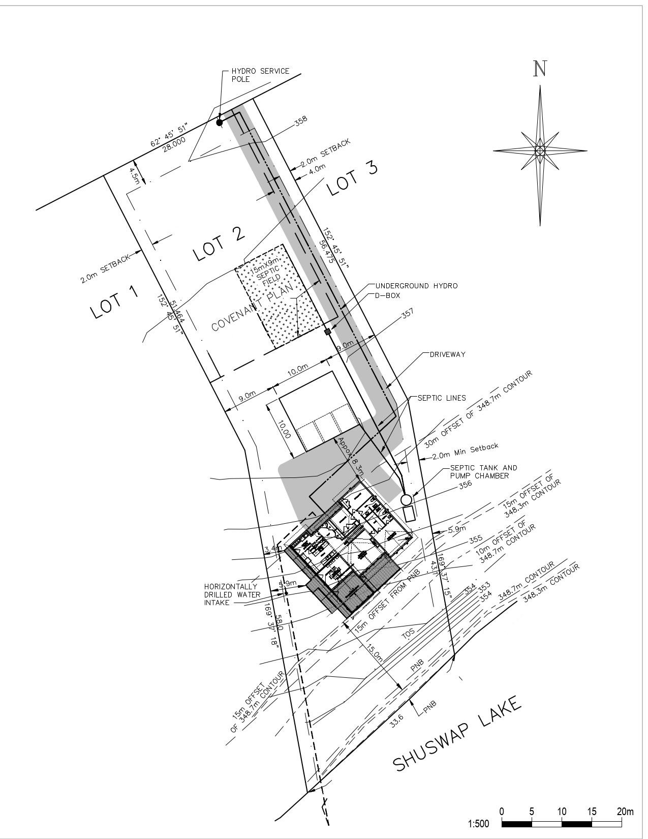
A site plan, prepared by a surveyor
A surveyor’s site plan for a new house on a lakefront lot in the Shuswap. Jay makes sure a plan like this shows what the regional district needs: setbacks, the septic area and covenants, contours and lake offsets.
Select either drawing to see it full size.
About Jay Simpson
Jay Simpson understands planning and permitting from both sides of the counter. Having served two terms as a CSRD Electoral Area Director and worked through applications for his own property and others, he knows how demanding—and frustrating—the process can be.
Through Applicai, Jay combines that practical experience with software that helps keep documents, deadlines and next steps organized. He represents your interests, communicates with regional district or municipal staff, and manages the follow-through that keeps applications moving. His goal is straightforward: take the burden off your shoulders and give you a clear path through the process.
Tell Jay about your property
A short email or call is enough to start: where the property is, what you would like to do, and anything you have already heard from the regional district or municipality.
Contact
Applicai Consulting — Jay Simpson2832 Simpson Road
Lee Creek, BC V0E 1M4
Canada
Phone: 250-222-6111
Email: info@applicai.ca
Are you a consultant or agent? See For consultants & agents.